
Warning Issued on Increase of Tropical Cyclones in August
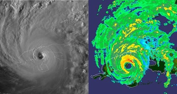
Imágenes de satélite y radar que muestran al ojo del huracán GUSTAV penetrando por la costa sur de Pinar del Río. Foto: Insmet
Compared to June and July, August records a significant increase in the formation of tropical cyclones in the tropical Atlantic basin, which includes the Gulf of Mexico and the Caribbean Sea—a trend that becomes more evident during the second half of the month, which, together with the first half of September, constitutes the peak period of cyclonic activity within the six‑month season in this geographical area, according to Professor Luis Enrique Ramos Guadalupe, coordinator of the History Commission of the Meteorological Society of Cuba.
Ramos Guadalupe also told the Cuban News Agency that for Cuba in particular, August ranks as the third month of highest impact risk, surpassed only by October and September. He recalled that between 1791 and 2022, the country was affected by 19 hurricanes in the eighth month of the calendar year, representing 16 percent of those that struck over those 231 years.
He cited as examples Charley of 2004, whose center crossed the southern coast of what was then Havana province in the early morning hours of the 13th, with Category 3 intensity on the Saffir‑Simpson scale, maximum sustained winds of 180 kilometers per hour, and gusts exceeding 200 km/h; and Gustav, a Category 4 storm that passed over the western portion of the Isle of Youth on the afternoon of August 30, 2008, and later made landfall in Pinar del Río province along the southern coast of the municipality of Los Palacios, causing extensive material damage in both territories. At its passage, the Paso Real de San Diego weather station recorded an impressive maximum wind gust of 340 kilometers per hour—the strongest officially reported in the Cuban archipelago.
Although they did not pass over Cuba, he also highlighted the cases of the renowned Andrew, which in 1992 devastated areas of southern Florida, and Katrina of 2005, which caused a disaster of great proportions in the U.S. city of New Orleans.
The primary zone for tropical cyclone formation in August lies in the open waters of the tropical Atlantic, between the coasts of Africa and the Lesser Antilles arc. Generally, these systems tend to move persistently westward and west‑northwest for several days, so some manage to enter the eastern Caribbean Sea and later move through the seas south of Cuba toward the Yucatán Peninsula, while others track near or over the northern coast of Puerto Rico and the Dominican Republic en route to the Bahamas and the southeastern United States. Historically, this type of trajectory has caused indirect impacts on Cuba from several August tropical cyclones whose centers never crossed over national territory.
However, in 2022, no named cyclonic system formed in the tropical Atlantic basin—a scenario that had previously occurred only in the seasons of 1941, 1961 and 1997.
Añadir nuevo comentario