
Iran Mocks Trump by Redesigning the Map of the United States
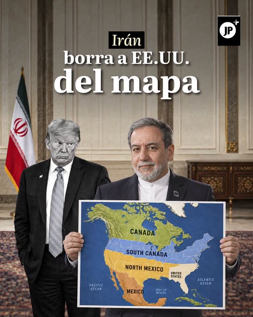
A new international controversy erupted on social media after Iran's embassy in Sierra Leone posted on its official X account (formerly Twitter) a satirical image redesigning the geography of the United States in a clear mockery of President Donald Trump.
In the map circulated by the Iranian diplomatic mission, U.S. territory appears erased and divided into only two regions.
Canada-Mexico
"South Canada" in the northern strip and "North Mexico" in the southern portion, while the Mexican Republic retains its usual name at the bottom. Meanwhile, the United States was limited to the country's original 13 colonies and Florida.
The provocative image was accompanied by the provocative message: "Finally, Canada and Mexico solved the world's biggest problem."
Posted last Sunday, September 6, the publication quickly went viral, reaching millions of views and tens of thousands of reactions.
Response to Trump's Controversies
Although the post does not represent an official territorial change, the satirical piece emerged in response to Trump's recent activity on his Truth Social platform and his constant controversies related to cartography and international history.
The diplomatic trolling coincides with the U.S. president's statements in which he publicly proposed renaming the state of New Mexico as "New America," as well as with another controversial post in which he claimed the Moon belongs to the United States.
His Fixation with Renaming
This is not the first time Donald Trump has been involved in disagreements over geographic names.
Among his best-known precedents is the replacement of the name Gulf of Mexico with Gulf of America in official references through an executive order.
In recent dates, the president also signed a similar decree to rename Lake Ontario as Lake America.
Añadir nuevo comentario