Published on Cuba Si (http://www.cubasi.cu)
Hurricane Matthew was upgraded to Category 2 just before 2 a.m. when Air Force hurricane hunters measured winds at more than 100 mph.
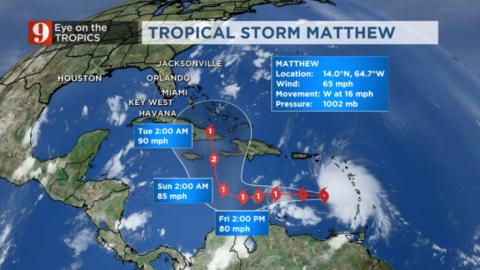
Matthew quickly grew in strength overnight and could pose a threat to Jamaica as it approaches Sunday night, Channel 9 meteorologist Brian Shields said.
"Matthew rapidly intensified overnight," he said. "It could be a dangerous hurricane as it gets close to Jamaica on Sunday night."
"It is still too soon to tell if Matthew will impact the U.S.," Shields added. "The next two days will be critical."
@BShieldsWFTV #Matthew will be very close to Jamaica as a dangerous hurricane on Sunday night... #wftv
The storm also continues to slow down, and is currently crawling west at 14 mph.
Hurricane Matthew is expected to meander around the central Caribbean through Saturday before making a northerly turn.
Although the system is about to approach an area with strong wind shear, Matthew is strong enough to sustain these winds aloft.
It is possible for Matthew to become a major category hurricane during the next 24 hours before impacting Jamaica and Cuba.

If the storm were over Florida, it would cover the entire state.
Computer models show Matthew’s course turning north by early Sunday morning, taking it over eastern Cuba by Monday evening.
The storm is moving slowly over the Caribbean and it is still too far out to know what, if any, impact it may have on Florida.
A tropical storm watch is in effect for Curacao and Aruba. The northern coast of Colombia from Riohacha to the Colombia/Venezuela border.
“The model data keeps Matthew east of us next week, taking it through the Bahamas,” Shields said. “We’ll monitor for any changes to the possible track.”