
Tropical Storm Fiona predicted to impact Puerto Rico this weekend with 60 mph winds
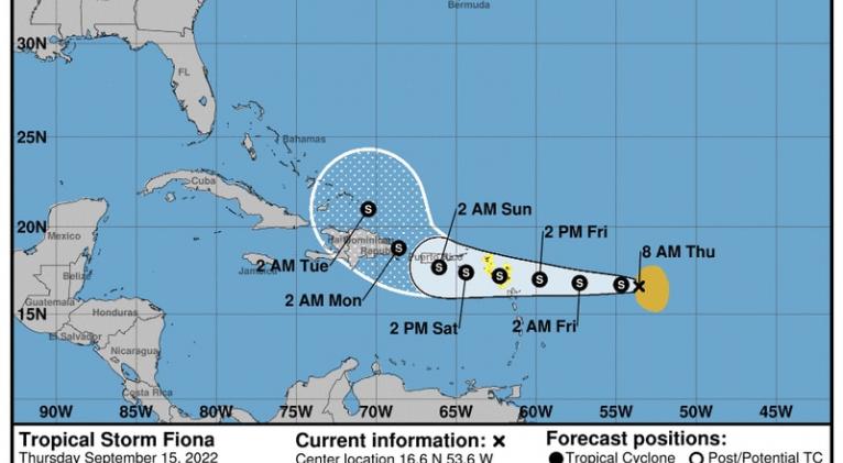
Tropical storm Fiona is continuing its westbound journey Thursday morning and should reach part of the Leeward Islands by Friday night before arriving in Puerto Rico and the Virgin Islands this weekend, the National Hurricane Center said.
The sixth named storm of the year didn’t change much overnight, according to Thursday morning satellite imagery. An Air Force Hurricane Hunter aircraft is scheduled to investigate Fiona later today. In its 8 a.m. update, the hurricane center said, “Fiona is moving toward the west near 13 mph, and this general motion is expected to continue for the next several days.”
As of the recent update, Fiona was located about 545 miles east of the Leeward Islands. Maximum sustained winds were estimated at 50 mph with higher gusts. Fiona’s tropical storm-force winds extend outward 140 miles from Fiona’s center.
Tropical Storm Watches were issued for St. Maarten, Antigua, Barbuda, St. Kitts, Nevis, Monserrat, Anguilla, Saba, and St. Eustatius. Additional Tropical Storm Watches will likely be issued Thursday for the Virgin Islands, Puerto Rico, and Hispaniola.
At around 10 p.m. Wednesday, Fiona became a tropical storm when satellite data showed Tropical Depression 7 had strengthened, maintaining maximum sustained winds greater than 39 mph. It is not yet known if the tropical storm would impact Florida or the mainland United States. Most projected storm paths show Fiona making a hard bend northeast away from the Sunshine State.
Forecasters aren’t impressed with Fiona’s structure, calling it “sheared” and “asymmetric,” and suggesting the ragged form doesn’t yield itself to much strengthening in the near future. Hindering it further is a strong northwesterly wind shear expected to stymie the storm for the next few days. Conditions only get worse for Fiona as its core interacts with dry air and is potentially impacted by land interference while passing over portions of the Greater Antilles this weekend and early next week.
For now, the NHC says the storm could strengthen to 60 mph winds over the next 24 hours. On Monday, Fiona is expected to interact with the Hispaniola mountain range, which historically weakens tropical storm organization due to the mountainous terrain’s effect on the wind structure. However, predictions actually show Fiona’s winds growing in power to about 65 mph at around the same time it would be passing over Hispaniola.
The most significant impact the Caribbean islands may feel from Tropical Storm Fiona is from rain, which is expected to accumulate 3 to 6 inches in the Leeward Islands Friday night.
“Heavy rains will begin to affect the northern Leeward Islands late Friday, spreading into the British and U.S. Virgin Islands and Puerto Rico over the weekend,” the hurricane center said. “This rainfall may produce isolated flash and urban flooding, along with isolated mudslides in areas of higher terrain.”
Currently, hurricane season is in the middle of the most active time for tropical activity, between mid-August and mid-October.
Prior to the season, National Oceanic and Atmospheric Administration forecasters predicted 2022 to be yet another above-average season in storm production coming off the heels of two record-breaking seasons for named storms. The NOAA doubled down on its forecast at the start of August. However, the season has been off to a sluggish pace compared to past seasons.
Typically, the eighth named storm emerges by or before Sept. 9 and the third hurricane by Sept. 7, but the season has thus produced five named storms and two hurricanes. The NOAA’s prediction call for a total of 14-21 named storms by the end of the season, Nov. 30.


Add new comment